Quick Facts – Eysturoy

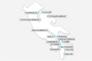
Name: Eysturoy, (East island) is the second-largest island in the Faroes.
Municipalities: There are 6 municipalities in Eysturoy.
- Runavík Municipality – the third largest municipality in the Faroes, and is comprised of 15 villages.
- Nes Municipality
- Sjóvar Municipality
- Eystur Municipality
- Sunda Municipality
- Eiði Municipality
Neighbouring islands: Eysturoy is located in the centre of the Faroe Islands. In addition to a bridge that connects the islands Eysturoy and Streymoy, there are two subsea tunnels linking the island to the neighbouring islands Streymoy and Borðoy.
Total land area of:
Eysturoy: 286.3 km2 (110.5 square miles)
Faroe Islands: 1,399km2 (540 square miles)
Heights: The highest peak is Slættaratindur 880m (2,887ft), which also is the highest mountain in the Faroes.
Climate: Average 3º-11ºC, winter-summer
Population:
Runavík municipality: 4.248 (April ’21)
Eysturoy 12.039 (April ’21).
Faroe Islands 52.656 (April’20)
Capital: Tórshavn (population 22,216 as of July ’20)
Status: Self-governing region within the Kingdom of Denmark
Language: Faroese. Danish has equal status in all official affairs
Religion: Evangelical Lutheran
Government: Parliamentary democracy
Prime Minister: Aksel V. Johannesen (Social Democratic Party, Javnaðarflokkurin)
Anthem: Tú alfagra land mítt
Main industries: Fishing and aquaculture, shipping and offshore services, tourism and prospects for petroleum in the Faroese area
Currency: Faroese króna (DKK)
Exchange rate: £1 = 8.27kr, US$1 = 6.31kr, €1 = 7.45kr (August 2020)
International telephone code: +298
Internet TLD: .fo
Time: GMT (winter); GMT+1 (summer)
Electrical voltage: 220V; European two-pin plugs
Weights and measures: Metric
Flag: Red cross fringed with blue on white background
Public holidays: New Year’s Day 1 January, Maundy Thursday, Good Friday, Easter Sunday, Easter Monday, Flag Day 25 April, Common Prayers’ Day (May), Ascension Day, Whit Sunday, Whit Monday, Ólavsøka 28-29 July, Christmas 24-26 December, New Year’s Eve 31 December


